| . |
| . |
| 1940-49 EQUIPMENT PHOTOS (Page 3) |
| The streetcars displayed on the next two pages were purchased by the D.S.R. during the 1940s. After World War-II, attempts were made to modernize the streetcars assigned to the last remaining rail lines. A total of 186 P.C.C. (President's Conference Committee) streetcars were purchased between 1945 and 1949. |
| . |
THE DSR's ST. LOUIS CAR COMPANY BUILT P.C.C. CARS
| . |
| . |
P.C.C. WOODWARD AVENUE OPERATION (THE CITY'S MAIN LINE):
| . |
| FOR GRATIOT, JEFFERSON and MICHIGAN P.C.C. PHOTOS (Part 2) CLICK-ON "NEXT" |
| . |
Even though the DSR purchased
numerous makes of motor coaches
during the 1940s, two large fleets of
P.C.C. cars were also purchased. The
following photos will highlight these
cars at work on the streets of Detroit.
For a more detailed look at the history
of these streetcars, see pages under
"The PCC Era"
numerous makes of motor coaches
during the 1940s, two large fleets of
P.C.C. cars were also purchased. The
following photos will highlight these
cars at work on the streets of Detroit.
For a more detailed look at the history
of these streetcars, see pages under
"The PCC Era"
© 2008 (PAGE LAST MODIFIED ON 01-06-10 (addition 10-07-11))
| . |
| . |
| . |
| . |
| . |
PHOTO: Car #136, east on Michigan Ave. at Vermont
(RV Mehlenbeck Photo, Krambles-Peterson Archive)
(RV Mehlenbeck Photo, Krambles-Peterson Archive)
| . |

| . |
| . |
| . |
| . |

| . |
| . |
| . |
| . |
All Walter P. Reuther Library, Wayne State University photos posted with permission.
All rights, including those of further reproduction and/or publication, are reserved in full by the Walter P. Reuther Library, Wayne State University.
Photographic reproductions may be protected by U.S. copyright law (U.S. Title 17). The user is fully responsible for copyright infringement.
All rights, including those of further reproduction and/or publication, are reserved in full by the Walter P. Reuther Library, Wayne State University.
Photographic reproductions may be protected by U.S. copyright law (U.S. Title 17). The user is fully responsible for copyright infringement.
| Please click-on link to return to the "PHOTO GALLERY" Main Page. |
| . |

| Prior to construction beginning on the city's Civic Center Project, Woodward PCC cars looped at the Detroit River via south on Woodward, west on Woodbridge, south on Griswold and east along Atwater back to Woodward. The above photo shows car #235 south along Woodward preparing to turn west onto Woodbridge street. Today, the Phillip A. Hart Plaza, a mostly concrete open-area riverfront public plaza and amphitheater, resides in this location. [photo courtesy of detroityes.com—Howard S. Babcock photo, Richard R. Andrews collection ] |
| . |
| . |
| HISTORY FOOTNOTE: The Donovan Building (designed by Albert Kahn and built in 1923) would later house the business operations for Motown Records (from 1968 to 1972). On July 23, 1968, Michael Jackson and his brothers (The Jackson 5) would audition for Motown Records at the Donovan. The building (a.k.a. The Motown Bldg.) was closed in 1974 and later demolished in January of 2006 after then Mayor Kwame M. Kilpatrick said it was an eyesore for visitors to the upcoming Super Bowl. [photo courtesy of the S. Sycko transit photo collection] |
| HISTORY FOOTNOTE: The site of the Veterans Memorial Building was at one time the location of Fort Pontchartrain du Détroit (Fort Pontchartrain on The Straits)—named by the city's founder, Antoine de La Mothe Cadillac, back on July 24, 1701. The original stockaded village covered an area bounded today by Larned, Griswold and Shelby streets, and just to the north of the current riverfront. The fort became known simply as Fort Detroit after the British gained control in 1760. If this was back in 1701, the PCC streetcar in the above photo would be in the Detroit River. [photo source: "Dave's Electric Railroads – DSR" — Joe Testagrose collection photo] |
| . |
| . |

| This photo shows the interior view of a typical DSR PCC streetcar. Unlike the Peter Witt cars they replaced—where the motorman was stationed behind a waist-level high hand-operated controller box—the PCC cars were built more like a transit bus, where the operator was seated to the left (not the center) and controlled the vehicle's speed with his feet (not his hands). The PCC's also came equipped with "standee" windows for standing passenger viewing, and from the center exit doors to the front, single forward-facing seats were used on the left-side of the car to allow for additional standing passengers during rush-hour high passenger load trips. [Walter P. Reuther Library photo #2845 — see disclaimer below] |
| During the last year of PCC operation along Woodward, cars were forced to detour as Woodward Avenue south of Jefferson was now closed because of construction on the city's new Civic Center. Cars detoured via west on Fort Street, south on Griswold, east on Jefferson and back to Woodward. In this photo, car #220 is turning from Fort Street, south onto Griswold. The former 10-story Hammond Building—the city's first skyscraper (built in 1889, and shaded in photo) is visible on the south side of Fort. The Hammond Building was demolished in 1956. [photo source: "Dave's Electric Railroads – DSR" — Stephen M. Scalzo collection photo] |

| Between the State Fairgrounds Loop and Six Mile Road, Woodward streetcars operated along an exclusive private-right-of-way along the center median of the highway. This helped to segregate the cars from automobile traffic and provided for faster travel along that portion of the line. In this photo, two PCC cars pass each other just north of W. State Fair street. Oops! ...It looks like the motorman in car #206 forgot to change his roll sign from "State Fairgrounds" to "City Hall." The Fairgrounds Loop loading platform area can be seen in the distant background to the right. [photo source: unknown collection photo] |

| Not only did the entrance to the Fairgrounds Loop differ from today, the loading area was quite different as well. This photo shows car #249 leaving the loop and about to head southbound on the Woodward line on its trip to downtown Detroit. Note the covered loading platform area and the adjacent building—a small restaurant and hamburger stand. [photo source: "Dave's Electric Railroads – DSR" — Joe Testagrose collection photo] |

| In this photo, car #131 (one of 78 cars from the 1947 order) is southbound along Woodward Avenue near Dakota W. street. The former Log Cabin Loop turn-around would have been just across Woodward Ave. in Palmer Park—one block to the north of where this photo was taken. On an interesting side-note: That "DOG HOSPITAL" sign displayed on that building in the right background is still visible today—although quite a bit faded—some fifty plus years later. [photo source: "Dave's Electric Railroads – DSR" — Stephen M. Scalzo collection photo] |
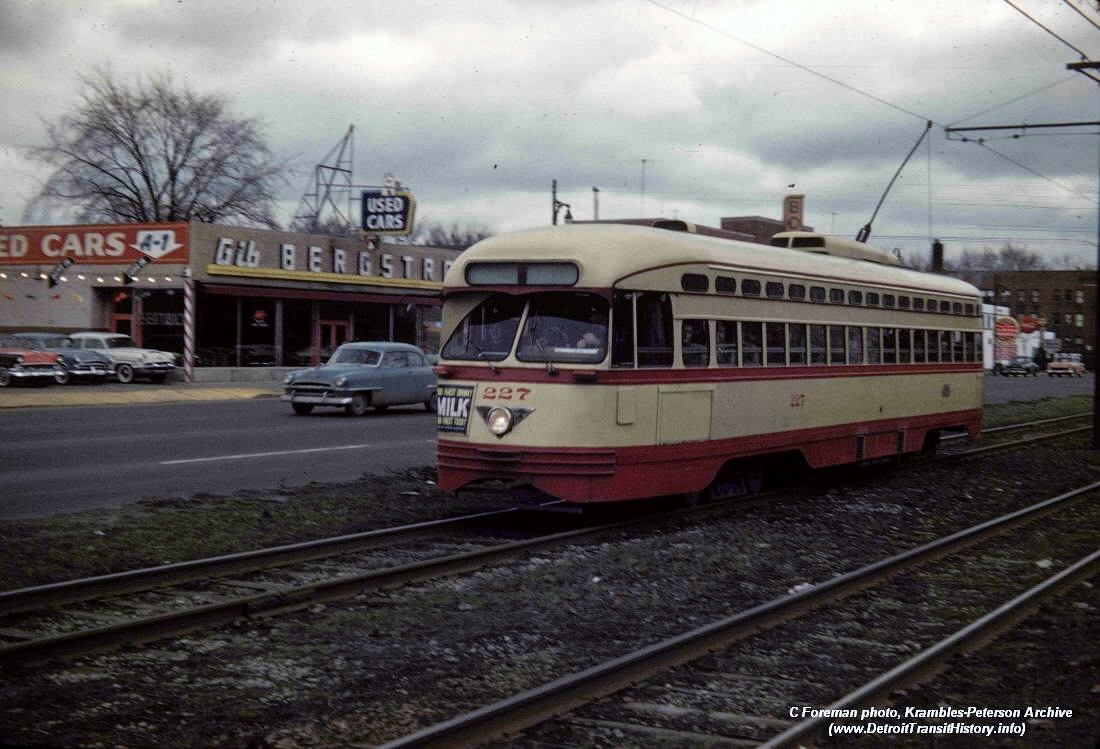
| Farther south along Woodward, mid-way between Seven Mile Road and McNichols (Six Mile), car #227 heads north along the center median PRW while between Savannah and Nevada streets (across from Palmer Park). Since the taking of this photo in 1955, Gib Bergstrom Used Cars and the Log Cabin Lanes bowling alley (hidden behind PCC car) have been remodeled and taken over by the Park Motor Sales/Lincoln-Mercury dealership, which closed its doors in late 2009. [photo courtesy of the Krambles-Peterson archive collection: C. Foreman photo] |
(Click-on photo to view larger image)

| In this 1954 photo, car #259 is east along Atwater Street, preparing to approach Woodward Avenue for the northbound return trip to the Log Cabin Loop turn-around in Palmer Park. The rear of the Veterans Memorial Building (which opened in 1950, and the first complex completed as part of the city's Civic Center Project) can be seen in the distant background. The rest of this area would soon be demolished to make way for Detroit's new Civic Center Complex. |

(Click-on photo to view larger image)
| In this April 17, 1955 photo, car #219 is southbound along Woodward Avenue, just south of Kirby Street (passing the Detroit Public Library–Main Branch, not visible in photo). The tall buildings in the background were originally known as the Wardell Hotel (built in 1926), later renamed the Wardell Shelton Hotel and then the Park Shelton Hotel. Turned into an apartment complex during the 1970s, the buildings were refurbished and converted into condos in 2004 and are known today as the Park Shelton Condominiums. (click-on photo for wide-angle view) [photo courtesy of the Krambles-Peterson archive collection: William C. Janssen photo] |
| HISTORY FOOTNOTE: The Donovan Building (designed by Albert Kahn and built in 1923) would later house the business operations for Motown Records (from 1968 to 1972). On July 23, 1968, Michael Jackson and his brothers (The Jackson 5) would audition for Motown Records at the Donovan. The building (a.k.a. The Motown Bldg.) was closed in 1974 and later demolished in January of 2006 after then Mayor Kwame M. Kilpatrick said it was an eyesore for visitors to the upcoming Super Bowl XL. |
| HISTORY FOOTNOTE: The site of the Veterans Memorial Building was at one time the location of Fort Pontchartrain du Détroit (Fort Pontchartrain on The Straits)—named by the city's founder, Antoine de La Mothe Cadillac, back on July 24, 1701. The original stockaded village covered an area bounded today by Larned, Griswold and Shelby streets, and just to the north of the current riverfront. The fort became known simply as Fort Detroit after the British gained control in 1760. If this had been back in 1701, the PCC streetcar in the above photo would be traveling within the Detroit River. |

| In this photo, car #235 can be seen traveling north along Woodward Avenue, just south of Fort Street. Not long after the streetcars on Woodward were removed in April 1956, the days would also be numbered for all the buildings visible in the background as well. Later that same year, all of the buildings within that entire block would be demolished to make way for the new 14-story headquarters for the National Bank of Detroit (NBD). That block included a number of landmarks familiar to Detroiters back in that day, including the ten-story Hammond Building— Detroit's first skyscraper (not seen in this photo), and the former Richmond & Backus Bindery and Printing Company office building (far left). Also note the Carling "Red Cap" Ale billboard ad, which also displayed the current temperature. [photo source: unknown photo] |

| In this photo, car #281 can be seen traveling south along Woodward Avenue, crossing Vernor Highway. This same intersection today would be Woodward and the I-75 (Fisher) Freeway overpass. The tall ten-story building in the background is the former Donovan Building, which at the time of this photo stood at the NW corner of Woodward Avenue and Duffield Street. |

| In October, 1945, two (2) demonstrator PCC cars arrived in Detroit to be tested on the DSR's heaviest streetcar route—Woodward Ave. Built by the St. Louis Car Company of St. Louis, MO, these two cars (#100 and 101), which were typical of PCC cars built prior to 1945, were of the "air-electric" type (which used a belt-driven air compressor to operate the doors and brakes). All future Detroit PCCs would be "all-electric" cars, and typical of cars built after WW-II. In this 1954 photo, car #101 can be seen at the DSR's Woodward Carhouse in Highland Park, MI. [Richard S. Short photo, courtesy of DSR-2-DOT discussion group member Dennis M. Linsky] |

(Click-on photo to view larger image)
| After May of 1947, the northern portion of the Woodward line ended at the State Fairgrounds. North of Six Mile Road, streetcars operated along the center median. In this 1955 photo, all auto traffic comes to a stop as car #247 prepares to enter the loop area from the median. During that time, about one in every third car traveled to the Fairgrounds Loop. Most Woodward cars, however, turned at the Log Cabin Loop in Palmer Park. (click-on photo for larger image) [photo courtesy of the Krambles-Peterson archive collection: William C. Janssen photo] |

| Although today, the remodeled Fairgrounds Loop used by the city's "all-bus" operation under D-DOT is primarily a concrete dominated environment, this photo shows the trees and greenery that once lined portions of the State Fairgrounds loop area during the streetcar era. [photo source: "Dave's Electric Railroads – DSR" — Stephen M. Scalzo collection photo] |


(Click-on photo to view larger image)
| This photo shows another view of that same intersection taken on June 19, 1951, back when DSR motor buses worked along-side the PCC's. An earlier version of a GM diesel coach (a later model of which would replace the PCC fleet) can been seen traveling southbound. The block in the background (bounded by Woodward Avenue, Fort Street, Congress, and Griswold) would soon make way for the new National Bank of Detroit (NBD) headquarters building. Today that building, located at 611 Woodward, was (until recently) known as the Bank One Building. It was officially renamed the Chase Tower in late April of 2006. (click photo for larger image) [Walter P. Reuther Library, Wayne State University photo #28313_2 — see disclaimer below] |

(Click-on photo to view larger image)
| This photo, also taken on June 19, 1951, gives a glimpse of the busy auto, transit and foot traffic experienced on a typical Tuesday afternoon in the Campus Martius area of Downtown Detroit. Today, Campus Martius Park resides in this location. The photo was taken while looking north along Woodward Avenue at Monroe and Cadillac Square. On the west side of Woodward sat the old Majestic Building, while on the east side Bond Clothes and Sam's Cut Rate Department Store sat where the Compuware Headquarters Building sits today. (click photo for larger image) [Walter P. Reuther Library, Wayne State University photo #28313_1 — see disclaimer below] |

| Woodward Avenue was the last streetcar line in Detroit to see the elimination of its rail service. Service ended on Sunday, April 8, 1956, when the last car pulled-in at 5:56AM. But later that afternoon, the DSR sponsored a special "end of the line" grand parade and final excursion along Woodward Avenue. That excursion, complete with police escort, included a parade of 24 PCC cars carrying nearly 2,000 passengers. This photo (taken from atop the Detroit Terminal Railroad overpass) looks north along Woodward Avenue, as lead car #285 heads the procession south along Woodward Avenue, just past Midland Street in Highland Park. [Walter P. Reuther Library, Wayne State University photo #2931 — see disclaimer below] |

| After the arrival of the two demo cars in 1945, two fleets of PCCs were purchased by the DSR. Seventy-eight (78) cars (#102-140, 142-180) arrived in the Spring of 1947, while the second order of 106 cars (#181-286) began arriving during the late Summer of 1949. By early 1950, 100% PCC operation was now possible on the Gratiot, Jefferson, Michigan and Woodward lines. In the above photo, car #279 can be seen at the DSR's Fairgrounds Loop on April 17, 1955. [photo courtesy of the Krambles-Peterson archive collection: William C. Janssen photo] |

| In this April, 1955 photo, car #232 is southbound along Woodward Avenue at Michigan, passing along-side the Majestic Building, seen in background. The 14-story Majestic Bldg. (built in 1896) was Detroit's third skyscraper, and reigned as the city's tallest building from 1896 to 1910. The former retail-office building was located on the northwest corner of Michigan and Woodward. The building fell to the wrecking ball in 1962 and was replaced by the black granite 25-story First Federal Building (currently the 1001 Woodward building) which opened in 1965. [photo source: Detroit's Street Railways Vol. 2 (City Lines 1922-1956), Willam Janssen photo] |
| THE 1990's 1 2 3 |
| THE 2010's 1 2 |
| THE 2000's 1 2 |